Lewis and Clark Expedition: Exploring the Route Map

The Lewis and Clark Expedition stands as a monumental chapter in American history, symbolizing the spirit of exploration and discovery. Following the Louisiana Purchase in 1803, the expedition sought to unveil the unknown territories acquired by the United States and to chart a course to the Pacific Ocean. The mission, which began on May 14, 1804, set out under the leadership of Meriwether Lewis and William Clark, aiming to unveil the vast landscapes that lay beyond the Mississippi River. This article will delve into the intricacies of the journey, utilizing a comprehensive Lewis and Clark Expedition route map to guide our exploration.
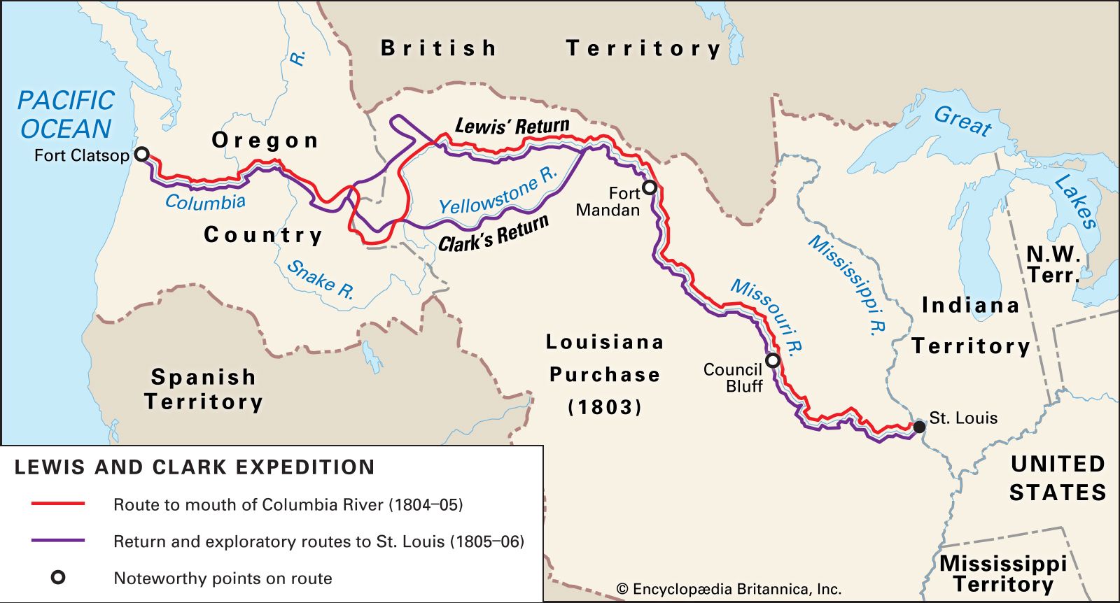
Understanding the Lewis and Clark Expedition maps of the route offers a glimpse into the challenges and triumphs faced by the explorers. As they traversed diverse terrains and encountered various Native American tribes, these maps highlighted their navigational skills and the sheer determination that propelled them toward their goals. In analyzing the map of the Lewis and Clark journey, we will uncover the narrative of exploration that not only changed the course of American history but also provided valuable insights into the geography and cultures of the western territories.
Overview of the Lewis and Clark Expedition
The Lewis and Clark Expedition was born out of the *Louisiana Purchase*, which effectively doubled the size of the United States. This vast expanse of land, stretching from the Mississippi River to the Rocky Mountains and beyond, was largely unexplored and unknown to the American public. President Thomas Jefferson recognized the need for an official expedition to survey this new territory, and thus the mission was formalized with the intent to find a practical route to the Pacific while documenting the area’s natural resources, scenery, and inhabitants.
The Louisiana Purchase: A Catalyst for Exploration
The Louisiana Purchase was pivotal not only in terms of land acquisition but also in igniting a sense of adventure and exploration among Americans. Comprised of approximately 828,000 square miles, this vast territory was purchased from France for about 15 million dollars. The historical significance of this transaction cannot be overstated, as it set the stage for **Meriwether Lewis** and **William Clark** to embark on their monumental expedition. Jefferson’s vision to expand American territory solidified the nation’s future growth, making it crucial for explorers to gather information about this newfound land.
The Leadership of Meriwether Lewis and William Clark
The successful execution of the Lewis and Clark Expedition was largely due to the capable leadership of Meriwether Lewis and William Clark. Lewis, chosen by Jefferson for his knowledge of science and wilderness skills, was appointed as the expedition leader, with Clark serving as his second-in-command. Their complementary skills – Lewis’s training in the sciences and Clark’s experience in military strategy and navigation – proved invaluable as they traversed the uncharted territories. The bond and camaraderie between the two leaders provided both the guidance and morale essential to the team’s endurance through the perils of exploration.
The Composition of the Expedition Team
The Lewis and Clark Expedition team consisted of a diverse group of individuals, totaling approximately 40 men. This group, often referred to as the “Corps of Discovery,” included skilled hunters, boatmen, carpenters, and herbalists. Their varied backgrounds greatly contributed to the expedition’s capacity to adapt to changing conditions and tackle the myriad challenges they encountered. Among them was renowned Shoshone woman Sacagawea, who played a crux role in facilitating communication and enhancing their relationships with Native American tribes, providing a bridge between the explorers and indigenous peoples.
Objectives: Exploring New Territory and Reaching the Pacific
The primary objectives of the Lewis and Clark Expedition were multifaceted, focusing on exploration, documentation, and establishing trade routes. With the ultimate goal of reaching the Pacific Ocean, the expedition sought to map the newly acquired territory, collecting data on plant and animal life and geographical features along the way. These efforts were documented in various Lewis and Clark expedition maps of the route, illustrating the progress and findings of the team as they navigated through the diverse landscapes of North America. The desire to foster relationships with Native American tribes and establish American presence in these territories was also a significant aspect of their exploration.
Encounters with Native American Tribes
Throughout the journey, the team met several Native American tribes, each with their own unique cultures and customs. The interactions were crucial for the expedition as they provided essential information regarding the geography and resources of the land. Key tribes encountered included the Oto, Missouri, and Shoshone, among many others. The Lewis and Clark map includes routes that show these critical interactions, demonstrating how each tribe contributed to the knowledge and safety of the expedition members. These encounters were not only about trade and negotiations but also about establishing mutual respect and understanding between differing cultures.
Challenges Faced During the Journey
The Lewis and Clark Expedition was fraught with challenges that tested the limits of human endurance and resolve. Among the foremost difficulties were geographic barriers such as mountains, swift rivers, and dense forests, which complicated navigation. Additionally, harsh weather conditions, including severe cold and relentless rain, posed further obstacles. Perhaps the most devastating challenge came with the death of Sergeant Charles Floyd, the only member of the expedition to die during the journey, which profoundly affected the morale of the Corps. These hardships are meticulously documented in various maps of the Lewis and Clark expedition, depicting the places where difficulties were encountered and the routes altered in response.
The Role of Sacagawea
One of the most significant figures in the Lewis and Clark Expedition was Sacagawea, who played an instrumental role as an interpreter and guide. As a Shoshone woman who had been captured by the Hidatsa tribe, Sacagawea's knowledge of the land and languages facilitated crucial interactions with various Native American groups encountering the expedition. Her presence not only signified peace but also helped ensure the safety of the team, particularly when they crossed through territories that were unfamiliar to them. The maps produced during the expedition highlight various landmarks and territories significant to her and her tribe, thus honoring her contributions to this exploration.
Key Milestones of the Expedition
Numerous milestones punctuated the Lewis and Clark Expedition, each representing a significant achievement toward reaching their ultimate goal. The Corps of Discovery famously crossed the continental divide, a pivotal moment in their mapping of the western territories. The discovery of the Columbia River was another key milestone, shedding light on a potential future trade route that would be essential for the burgeoning United States. Each of these critical points in their journey is marked on the map of lewis and clark journey, illustrating not only their geographical accomplishments but also the significance of their findings in American history.
Reaching the Pacific Ocean: A Historic Achievement
In November 1805, after nearly 18 months of grueling travel, the Lewis and Clark Expedition finally reached the majestic shores of the Pacific Ocean. This historic moment marked the culmination of their expedition, fulfilling the vision set forth by President Jefferson. The discovery of the Pacific was not just a personal victory for Lewis and Clark; it represented a monumental achievement for the United States, solidifying its presence on the western frontier. The excitement surrounding their arrival was palpable and is depicted in countless illustrations, alongside maps of the lewis and clark expedition, which showcase this momentous occasion in the timeline of American exploration.
The Winter at Fort Clatsop
The wintering period at Fort Clatsop was a time of reflection and resilience for the expedition team. Established near the mouth of the Columbia River, the fort became a strategic hub for the Corps of Discovery over the winter months of 1805-1806. The harsh weather conditions and limited food supplies tested the expedition's endurance, yet this period also provided an opportunity to document their findings and prepare for their return journey. The map of Lewis and Clark expedition depicts the temporary encampment and the distance traveled as the Corps braved the elements to complete their mission successfully.
The Return Journey: Exploring the Missouri River
In March 1806, after a prolonged stay at Fort Clatsop, the Lewis and Clark Expedition began its return journey. The team revitalized their spirit, utilizing their acquired knowledge and resources to navigate back through the treacherous terrains they had traveled. Revisiting the Missouri River was particularly significant, as they retraced their steps and observed the changes that had occurred during their journey. The return journey marked a continuation of their legacy, culminating in one of the most comprehensive mapping endeavors of the time, beautifully captured in the Lewis Clark map. As they traveled, their findings contributed to the growing body of knowledge about the American West.
Conclusion: Legacy of the Lewis and Clark Expedition
The Lewis and Clark Expedition left an indelible mark on the history of the United States, revolutionizing the understanding of the American landscape and indigenous peoples. The detailed Lewis and Clark Expedition maps of the route serve as a testament to the bravery, curiosity, and perseverance of the expedition team. Their encounters with Native American tribes, extensive documentation of flora and fauna, and the ultimate arrival at the Pacific Ocean became a foundational narrative that shaped the country’s westward expansion. The methodologies of exploration and their experiences resonate in contemporary narratives, reminding us of the profound legacy left by Lewis and Clark and the enduring spirit of exploration encapsulated in the map lewis clark expedition. Through their journey, they not only charted new lands but also opened the door for future generations to engage with, appreciate, and learn from the vast and diverse landscapes of the United States.
Did you find this article helpful? Lewis and Clark Expedition: Exploring the Route Map See more here Education.
Leave a Reply


Related posts